Snowshoeing and pulka sledding on the Vercors High Plateaus (nature reserve)
January 29: A white paradise
![]()
https://www.youtube.com/watch?v=t5Ravy6wviE
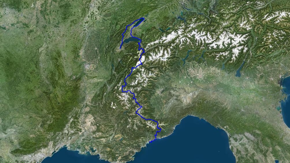
Several routes exist for crossing the Alps by mountain bike: it all depends on the starting point, the finish line, and above all, the time you have available. In hindsight, the difficulty of a route is mainly measured by the "rolling" aspect of the trail: anyone embarking on such an adventure should know that there will be moments of doubt, a few drops of sweat, and great joys. I start with a blank sheet of paper and solve a simple equation: my vacation is 30 days, or about 1200 kilometers at a rate of 40 km/day. Then, I take a map, choose some mountain ranges, and mark two points: a starting point in Geneva and a finish in Nice: an international trip of sorts.
On paper, the adventure looks fantastic. But the sheet quickly becomes an illegible draft. I draw curves, make notes, crosses, circles, and scribbles. The route takes shape, with a major inconsistency right from the start. The journey, theoretically a straight north-south line, becomes a random route heading due north for the first few kilometers. To stay on course, I take a compass, adding a few extra grams to a mountain bike that weighs over 30 kilos.
I set off with Valérie, my longtime riding partner, on July 14, 2014. Together, we traverse valleys and climb legendary mountain passes: a total of 34,000 meters of elevation gain. Our tent and fully loaded panniers are strapped to the bikes: we have enough supplies for up to four days, allowing us to resupply in remote mountain villages. The bikes are ready, and so are our legs.

The adventure begins in the Swiss Jura, a way of avoiding overexertion right from the start. The Creux du Van is an irresistible urge that the rain of the first few days doesn't deter, except when you have to take shelter from downpours in public restrooms or churches. It's good to relieve yourself in these unfortunate moments. The ibex at 6 a.m. and the colors of the sunrise at the Soliat cross make this 250-kilometer detour worthwhile. The return via Lake Neuchâtel is a true epic: the path is impassable with fallen tree trunks, vines, and brambles. You advance meter by meter through this jungle, your feet sinking into 20 centimeters of mud. The ground hasn't yet absorbed the recent rains.


To reach Chamonix, we climb via Salvan and Finhaut; the forest track is carved into the rock. The hairpin bends that take us ever higher make us dizzy and send the altimeter into a frenzy. The few welcome breaks relax our legs and arms, especially as wild strawberries and blueberries twinkle along the edge of the path. The descent from the Col des Montets is made in torrential rain; it's cold, and we're completely soaked. These conditions are the hardest for me to bear: when you're on a multi-day hike, it's impossible to properly dry your things (especially your shoes). I arrive in Chamonix wearing flip-flops and a canary-yellow poncho, adding a splash of color to the gray weather. Mont Blanc is shrouded in clouds; we won't see it.


A thick fog stops us in our tracks, forcing us to spend a second night in a mountain refuge, but the Beaufortain region holds a beautiful surprise for us when we wake up: a vast blue sky. Mont Blanc rises before us, as majestic as ever, and the Pierra Menta is reflected in the turquoise waters of Lake Roselend. After three mountain passes over 2,300 meters, we reached the Tarentaise Valley with an exceptional descent: 2,700 meters of negative elevation in a single day—a dream come true!


We set off again, clean (it won't last…), towards the Emparis
plateau, facing the Écrins massif where the peaks flirt with
4,000 meters. The area is perfect for mountain biking; the singletracks
are very smooth with ever-more beautiful scenery. Sometimes the descents
are quite technical, especially with the panniers on the front fork:
the bike, too heavy, takes completely wild turns, and I'm constantly
fighting to tame my machine, which could send me into a ditch at the
slightest lapse in concentration.


After a quick stop in Briançon to refill our panniers, we continued on to Cervières and the Col de l'Izoard. The landscapes changed with every pedal stroke, the vegetation adapting to the Queyras hills. The sweet scent of pine and larch trees tickled our nostrils: we were truly entering the south of France. With two mountain passes crossed, this was the most hilly day, with over 2,100 meters of cumulative elevation gain. As always, the journey is punctuated by improbable encounters in the middle of nowhere. We find shelter at 2,000 meters altitude because the weather is threatening. Five students are waiting for us there… with sausages, pork chops, green salad, beers, and more. We haven't eaten such a feast in 20 days: we're starving. Finally, the night is starry; it's Mont Viso in the distance, being struck by lightning.


To reach the Col de l'Arche and the Stura Valley, we have to go back up the Ubayette River; the trail is dizzyingly steep before disappearing completely: a rockfall has swept it away. There's only one solution: cross the stream in 60 cm of water and a strong current, being careful not to let go of the bikes. Once in Italy, things got serious with the ascent of the Becco Rosso pass, at 2260m. It wasn't the altitude that was the problem, but the very steep slope… For the first time, we were exhausted, our legs felt heavy, the bikes became a burden that we had to push with all our might, and our morale plummeted for the three-hour climb. At the summit, we decided to take a long break: we were completely lethargic despite the blueberry fields surrounding us. The descent was much more enjoyable, our batteries were fully recharged.


Even though the Casterino valley is generally downhill all the way to Tende, the morning is tough; it's hard to pedal. There are days when your body just doesn't respond as you'd like. Short breaks become more frequent and disrupt the rhythm even further. Any excuse is good enough to stop: a photo, wild strawberries, a drink or a cake, a drink and a cake, a chat, and so on. It has to be said, the place is sublime: the Mercantour National Park and the Valley of Wonders are right in front of us. After La Brigue, we laboriously climb back up towards the Baisse de Sanson: this time, Val sets the pace. There's nowhere to pitch our tent, so we're forced to continue at a speed of 4 km/h; I might as well have walked up.


This morning, you have to get up early, very early indeed, to see the sun. By 6:30 a.m., the sky is already darkening. We barely have time to get on the saddle before it starts raining—a little, a lot, passionately. Luckily, the Muratone shelter protects us—or rather, a piece of corrugated iron, since the huge Muratone refuge is closed. The jerrycans placed under a gutter fill with rainwater in minutes and are our only distraction at the moment. To pass the time and warm up, we make mint tea; our instant coffee supplies have been depleted for several days… as have our food rations. We have a piece of cheese and a can of sardines left.


After Sospel, we climb our final pass, the Razet, peaking at 1032 meters—a monster! The trails are very smooth, it's pure bliss. We're excited about our arrival, both happy to have completed such a wonderful trip, rich in emotions and sensations, but a little sad that we can't continue, even though today there are no more roads; the sea stretches out before us…

https://www.youtube.com/watch?v=t5Ravy6wviE
HD1080 16:9 MPG4 h264
Duration : 26 min
Language : FR /French
Subtitles : English
Master DVD : 3,1 Go
17200 Kbits/sec
2015 - Festival de Lugano, Suisse - Matera Sport festival, Italie - ICFF Cycling Film Festival, All. - Adventure festival, Athènes, Gr. - BFF Bansko, Bulgarie - Festival outdoor, Prague, CZ - 2016 - Flix film festival, Canada - Mets d'la wax, Valmorel - Gala du film de Pau - Du bout de la rue au bout du monde, Colmar - Cycle Touring Fest, Clitheroe, UK - EuroVeloGex, Crozet - Le Vénéon fait son cinéma, St-Christophe-en-Oisans - La Bérarde - Festival Teplice nad Metují, CZ - Bisiklet Filmleri Festivali, Istanbul - Overtime festival, Macerata, It. - Echo festival, Skopje, Macédoine - FFME Horace Bénédict, Nancy - Montagnes du monde, Foix - Bovec festival, Slovénie - 2017 - Cyclo camping CCI, Paris - Festival Ici-là bas, Nancy - Soirée CAB, Bruxelles - Vel'Osons, Chambéry - Arrivée UT4M, Grenoble - Défis de l'aventure, Fontanil - Soirée montagne, Mizoën - 2018 - La roue tourne, Toulouse - Rêve de Montagne, Vétraz - 2019 - Festivelo, Lausanne - En roue libre, Bruxelles
MOUNTAIN GUIDE
Trekking leader / Travel agency
EXPEDITREK
38880 Autrans, Vercors - France
Mobile cell phone +33 (O)6 88 76 54 7O
See you soon with Whatsapp